London is a fantastic place to go walking. There’s so much to explore, and for a densely urban area it does have a good amount of green space. However, sometimes the hustle and bustle of the city can become overwhelming, and escaping the city can be a more attractive prospect. Luckily, London is surrounded by some lovely countryside, from the varied Surrey Hills to the rolling landscape along the South Downs Way. We’ve compiled three of the best walks near London, to help get you out of the city and into the great outdoors. Each route connects to regular trains from central London, and can be followed using an Adventure Atlas map book.
Surrey Hills – Wanborough to Godalming
Distance: 7.5 Miles
From London Waterloo you can get to Wanborough by train in under an hour. The route will take you past the incredible Wanborough Manor and up over the oddly straight ridge of the Hog’s Back. Join the North Downs Way until you reach the amazing Watts Gallery and Chapel, once home to Victorian painter and sculptor Frederick Watts. Eventually, the route arrives at the historic market town of Godalming where you can get a direct train back to Waterloo every half an hour.

Thames Path – Windsor to Bourne End
Distance: 12 Miles
Windsor is easily accessible by train from either Paddington or Waterloo station. On arrival, the Thames Path takes you away from the castle and across the river out of Windsor. After 2 miles you’ll reach the prestigious Eton Dorney, a £17M purpose-built rowing lake that is privately owned by Eton College. The walk continues past islands, weirs and marinas, and into the outskirts of Maidenhead. Follow the river north through some of the finest countryside the Thames Path has to offer, before eventually arriving at Bourne End station. A branch line connects back to Maidenhead for the return journey to London, where you can reflect on one of the best walks near London.

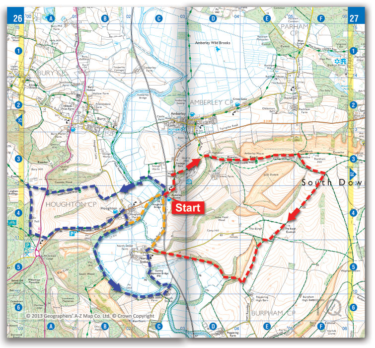
South Downs Way – Choose your route around Amberley
Distance: 5 – 15 Miles
Amberley nestles below the South Downs, near a gap where the River Arun carves its way through the chalk hills. Amberley station is a one and a half hour ride from Victoria, with trains running hourly.
The map below shows various options for circular routes from Amberley station, giving a range of walks that vary from around 5 miles to a challenging 15 miles plus. The sections of the South Downs Way east and west of Amberley station both head up into classic downland, although the western loop is more wooded and the views aren’t quite as extensive. The paths along the River Arun offer a different terrain. Look out for the suspension bridge on the footpath between North Stoke and South Stoke, which was recently repaired by the Ghurkas. Be aware that the riverside paths can be covered by flood waters, so avoid these after lots of wet weather.

Please comment with your suggestions for the best walks near London.