The A-Z Adventure Atlases provide accurate and detailed OS Explorer mapping in a slim book format. Walkers and other off-road adventurers can now carry their Ordnance Survey (OS) mapping in a convenient single indexed book, rather than as a large sheet map. In this week’s blog, we explore this new series of maps, which turns out to be a unique product of two British institutions that began in the 1930s.
About OS Explorer mapping
The distinctive orange covers of the OS Explorer and Outdoor Leisure maps will be recognised (and often cherished!) by walkers, off-road cyclists, horse riders and other countryside explorers around the country. The OS describe the Explorer maps as the only national map series covering the whole of Great Britain. Our older readers might remember the green-covered Pathfinder maps which they replaced. The 1:25,000 scale mapping they contain has its origins in the switch to a metric national grid, before WWII. In 1938, the Davidson Committee reported on the future of the Ordnance Survey. One of their recommendations was to adopt 1:25,000 scale maps as a national standard. The Director General, Malcolm MacLeod, rightly understood how useful the public would find these maps.

The Adventure Atlas concept
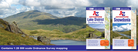
Around the same time, A-Z were starting out as the Geographers’ Map Company Ltd. A-Z have also built a reputation on providing clear and authoritative mapping, initially for London and now for many towns and cities across Great Britain. A-Z has now applied the concept of the pocket book to the trusted mapping from our national mapping agency. The mapping used can be seen in the image below.
The Adventure Atlases use standard OS Explorer mapping, but add an index to help quickly locate settlements, landmarks and places of interest. The laminated covers contain a flap that can be used as a bookmark, so the book can be instantly opened at the required page. A double page spread covers nearly 4 miles by 4 miles, so many short walks will fall within a single page. Each Adventure Atlas contains a number of useful QR codes that link directly to sites containing relevant local information. Read more about the Adventure Atlases.
Reviewers’ comments
The Atlases have been well received, with some reviewers surprised that such helpful innovations in printed mapping are still possible. Walkers who are used to folding and re-folding large OS map sheets have praised the format, and commented that they will be particularly helpful in windy weather and for planning routes while on public transport. The portability and affordability have also been welcomed. Experienced walkers have noted that only the protective covers are waterproof, but were happy to find that the slim and lightweight books fit in their existing waterproof map cases.
What areas are covered?
A-Z Adventure Atlases already cover some of the most popular areas for outdoor activities: the Lake District, the Peak District, Dartmoor, Snowdonia and the Broads. The whole South West Coast Path is covered by five guides, avoiding the need to buy and carry many more map sheets.
 Look out for new A-Z products coming out, and sign up for the Newsletter to receive occasional updates from A-Z.